Map Editor Suggestions
Welcome to the Map Editor's suggestion box!
This is the place to share your ideas for improving the Waze Map editor.
772 results found
-
Allow addition of new traffic signal or stop sign where one did not previously exist.
Allow editors to add a new traffic signal or stop sign. Allow alert similar to RR crossing sound. Set alert to expire 30-45 days after signal or stop sign is put into service.
4 votes -
Issue tracker filter incorrectly showing drop down menu arrow direction
In the issue tracker filter settings, currently the drop down arrows in the map issues filter settings for UR, PUR, MP and map suggestions are showing an up arrow when collapsed and a down arrow when expanded.
However, in other best practice design scenarios, it should be the other way around. That is, when collapsed, show a down arrow so when you select it, the menu expands. Likewise when the menu is expanded, show an up arrow so when you select it, the menu collapses. This is done correctly in other dropdown menu options in WME
I have attached an…
4 votes -
Addition of danger on the road: Smoke
Users should have the possibility to report a common danger in the road: Smoke. It can be from wildfires as described in another suggestion, however roads are not necessarily closed.
We have dangers like "ice on road" or "snow", however those are never used in countries where winter never gets below 0°C (or is highly unlikely). On the contrary, every year there are fires causing road hazards with visibility dropping considerably.
Related:
https://waze.uservoice.com/forums/59225-map-editor-suggestions/suggestions/41401828--wildfire-alerts4 votes -
School Zone reminders for Australia
it would be great if you could add the school zone reminders as we enter / approach a school zone area
4 votes -
Emergency Closures and Events/accident reporting
Allow users to add more than one section of road to a road closure.
It would be good if emergency closures would show up in the app to influence driving directions, and if we could report closures longer than one section of road.
I was driving somewhere on the weekend, and there'd been a fatal accident on the Highway at 2 am, but Waze still told me to drive using that section of the highway.
When I looked the accident had been reported on the app hours before I left, and there were comments on the accident about what sections…
4 votes -
4 votes
-
fietsers
waarom geen versie voor fietsers? niet alle wegen voor auto's zijn geschikt voor fietsers en vice versa
4 votes -
Save Routes
The app should allow people save in their profile or favourites , the routes that they consider better for use it to arrive at some frequent or general places
4 votes -
Radar ou Câmera De Monitoramento?
Implementar opção para informar se é câmera ou radar: se alguém marcar um novo radar, aparecerá a popup no canto inferior para outros usuários reportarem se é radar ou câmera. Após 1000 usuários "votarem" o aplicativo assumirá o mais votado. Como por exemplo o ponto https://maps.app.goo.gl/7vGVeH3dbH6oodDB7 que possui radar de velocidade nos dois sentidos mas não consigo informar isto.
4 votes -
tollbooths
To enable users to update the cost of the tollbooth.
4 votes -
Speed pumps alert
Lots of speeding pumps are not correctly feasible, would be real helpful if we can add report to the map as well
4 votes -
Exempting some editors from waiting for changes to be applied to the map
Hi .
I don’t know if Waze can exempt some editors who dedicated their lives to editing from the 24-hour waiting period for changes.
Several reasons support this idea:
such as editors having limited time due to family and work commitments.
Some actions require immediate attention, and exceptions could enhance map accuracy, accelerate change application, and impress users with faster updates, attracting new users.Your thoughts stemmed from adding a Gate to a mall, experiencing instant change app, prompting the idea of applying this efficiency to the entire map.
thanks!
4 votes -
Horrible new display! Wrecked into a ditch what happened to the exit numbers
WHY would you put the miles left ABOVE the exit you’re supposed to take? And what’s worse is you also make the long names of the exits the SAME font size as the exit number. I’m in Atlanta and almost had a wreck because I was so dang busy reading the stupid street names of the exit and the miles left, I barely could see the actual EXIT NUMBER and had to run into a ditch desperately trying to read where the exit number was. Please reconsider changing it back b cause I was not ready for that. Splot seconds…
4 votes -
Add More Culture / Entertainment Subcategories
It would be nice to have more subcategories for Culter/Entertainment venues. A couple of examples would be Bowling Alley and Arcade. When I look at bowling alleys in Waze they are flagged as the the main category, but I feel having a subcategory for them would help with users locating them.
I don't think this is too much to ask when we have subcategories for Race Track and Theme Park which is significantly fewer in number.
A list of culture/entertainment subcategories that come to mind that would be helpful:
- Bowling Alley
- Arcade
- Mini Golf (Putt-Putt)
- Escape Room
4 votes -
Keep usernames in WME history instead of "inactive user"
Whenever an user is banned or deletes his/her account or just mysteriously (!!) loses his/her account, all edits in history will be shown under name "inactive user" with a link to 404 page.
Just, for the sake of history, please keep the original username in history and add a little remark that the account is inactive/deleted/etc..
4 votes -
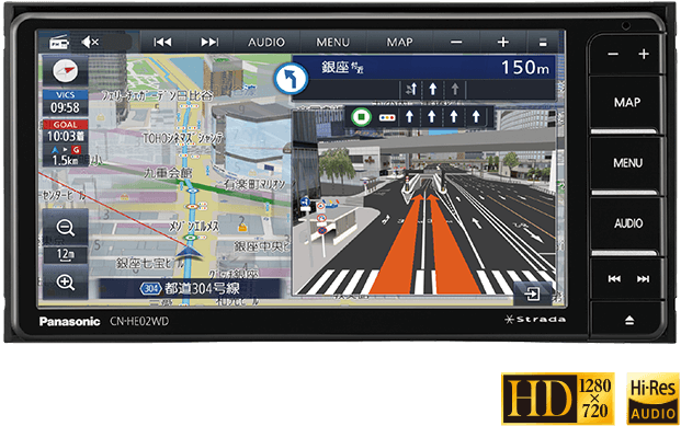
I would like to see a navigation function with detailed diagrams. (Since I am using a translation function, the text may be unnatural.)
nice to meet you. I am editing waze maps in Japan. I don't speak English so I use translation software. Therefore, there may be some parts of the text that are incorrect, so please forgive me.
Japanese car navigation systems have a function that displays a diagram that reproduces the shape of the intersection and which road to turn to when passing through an intersection or junction. However, that feature only supports some intersections.
It looks like the diagram on the right side of the screen in this image: https://panasonic.jp/car/navi/products/HA02_HE02/img/top/pic_01.png
Therefore, I would like to request that waze introduce such…4 votes -
In alerts, add a button to report that there is a fixed speed bump in the road.
In the alerts the user can report, having a button to report that there is a fixed speed bump in the road would be useful.
4 votes -
Natural sequence for house numbers
Is necessary to enable the insertion of house numbers that are a sequence of natural numbers (Ex.: 101, 102, 103, 104, ....), which is very common in several condominiums in Brazil.
4 votes -
Allow the toggle of speed camera notification
Currently it seems you only get notified of a speed camera when going above the speed limit. Which admittedly comes in handy most of the time however when smart motorways reduce the speed limit, Waze won’t notify you fully, compared to if you were going above the speed limit of a normal motorway. Possibly either inform you fully all the time or allow there to be a setting for people that wish to use this feature would be very helpful.
4 votes -
Average Speed Camera Location
Give the ability to pinpoint the location of the camera's that are being used for ASC's.
It adds another layer of information (besides the speed check zone announcement) to the map and avoids users reporting these ANPR-camera's as regular speed camera's.
4 votes
- Don't see your idea?