
Map Editor Suggestions
Welcome to the Map Editor's suggestion box!
This is the place to share your ideas for improving the Waze Map editor.
792 results found
-
Fix "House number already exists" error.
When adding HNs, if a particular number and street name combination exist anywhere else in the state, you get an error message that the HN can't be added because it already exists on the street.' It's not unusual for a street name to be used many times in other cities in the state.
What's even more frustrating is when the HN has been on the street for YEARS but in the wrong position but all you do is try to move it to the correct position and you get the "House number already exists" error.
There are work-arounds to force…
3 votes -
Add destination after the actual destination (optional)
When I add a destination when it is already one destination, it adds before the actual destination. I would like to have the option to add after the actual destination
3 votes -
Alpha Sort Shield picker display order
Need to alpha sort Shield Picker and place all generics (County Road) at the top. This was fixed shortly after the NA MMU in Seattle, but has reverted in subsequent releases.
3 votes -
Add an “Aerial Traffic Enforcement / Aerial Patrol” report type.
Currently Waze users often report helicopters monitoring traffic using generic police or hazard reports, which creates inaccurate map data.
A dedicated temporary aerial-surveillance event would improve report quality and traffic awareness, especially on highways where helicopter presence influences driving patterns over large areas.
Suggested characteristics:
temporary event
larger visibility radius than regular police reports
optional direction of travel
low-noise notification style
community confirmation required3 votes -
SAFEST not FASTEST route
This might not be relevant to users in very safe countries, but if you live in or travel to some South American or African countries (or even in some districts of the US), you do not necessarily want to get the fastest route, but the SAFEST one – omitting dangerous areas (like gang zones). As a concrete example, I was driving through Rio de Janeiro and Waze suddenly tried to reroute me through a Favela, because it was supposedly a few minutes "faster" (something, travel guides and the State Department even explicitly warn about). In fact, there were already news…
3 votes -
Schedule speed limit changes
Allow editors to schedule speed limit changes. For example during roadworks there is often a reduced speed limits. It would be useful to be able to set, in the editor, a start and finish date for these reduced speed limits. This would prevent an editor changing the speed limit and forgetting to change it back. This could be tied into tile builds so the edit is made in time for that days tile build.
3 votes -
El número de casa en Colombia está al final de la dirección
En Colombia, las direcciones se estructuran indicando primero la vía donde está situada la puerta, seguida del número de la vía de intersección con el símbolo #, y finalmente el número de la casa. Por ejemplo, Calle 67 #39-44: la puerta está sobre la Calle 67, la intersección más cercana es la Carrera 39, y el 44 corresponde al número de la vivienda. Por lo tanto, no está bien que en WAZE las direcciones empiecen con el numero de casa, como se muestra a continuación: 44 Calle 67 #39-44.
//
In Colombia, addresses are structured by first indicating the street…
3 votes -
Türkiye: Integrate official Ministry of Interior radar, checkpoint, and average-speed corridor data
Waze should consider integrating official public traffic-enforcement data for Türkiye from the Turkish Ministry of Interior:
https://www.icisleri.gov.tr/iller-arasi-radar-ve-kontrol-noktasi-uygulama-sayilari
This official page allows drivers to view the number of speed corridors, radar controls, and police/gendarmerie control points on selected intercity routes. According to the Ministry page, the data covers traffic applications carried out by Police and Gendarmerie units on the selected route and is refreshed every 30 minutes.
Adding this data to Waze would be very useful for drivers in Türkiye, especially on intercity routes. The goal would not be to help drivers avoid the law, but to improve road-safety awareness and…
3 votes -
Car Play - Heads up Display Integration
Google maps and Apple maps has this feature.
With my car, I have a heads up display feature.
The direction arrows and lane arrows will show up on the heads up display.I'm not sure what tech this is actually linking into to do this, but I would love this feature.
3 votes -
Proposal: Improve Access to Event Announcement Pages from the Live Map
Hello Waze Team,
Currently, the Waze Live Map does not provide a link button to event announcement pages. In addition, event detail pages do not include a button to return to the Live Map or the event list.
As a result, when users share an event detail link on social media and others try to check additional road closures afterward, they have no way to navigate back, which causes the experience to break down.
To improve usability and navigation, I would like to request the following enhancements:
Add a link button to event announcement pages on the Live Map
Add…
3 votes -
Don't detour off tolled highway and back on to save a minute
This morning waze thought it could save us a minute by directing us to exit the tolled highway. Take some back streets and then put us back on the same tolled highway. It didn't save us time but did cost us twice the amount for the trip.
Waze should not detour off and on tolled roads for insignificant time saving.
3 votes -
Do not automatically re-add a deleted GeoClosure RTC
Once a GeoClosure RTC is deleted, it should not be automatically re-added to the map.
1) It interferes with adding the actual RTC, where it will be automatically re-added during the process of adding the actual RTC which most of the time involve the painstaking process of selecting many segments, only to get hit with a "overlapping time" error.
2) Occasional issue of an inaccurate RTC reported, and is being removed by an editor with on-the-ground knowledge. Only L5 and SM+ are able to add RTCs in Malaysia, surely these editors are more trustworthy on the ground than users who…
3 votes -
BMW Connected Drive App version
A standalone application for BMW iDrive (Android Automotive), available via Connected Drive store and integrated with car instruments.
3 votes -
€ per minute saved for highway route with tolls
I find myself always going against Waze’s route on my daily commute, because it suggests taking the highway right at the start of the journey, instead of going a bit by the main road until the next city and then joining the highway. This happens because the highway is the fastest route, but the other option is just 4 min extra time in the morning and saves 2 euros in tolls which is half the cost of the journey, if I would take the 100% highway route.
There could be a feature, where I could say how much 1euro should…3 votes -
Avoid toll roads
I have “avoid toll roads” enabled but Waze still includes them. It’d be great if I could “drag” my route and save it as my preferred route.
3 votes -
Warn editors before hitting the daily proposal limit instead of failing on save
Currently, Level 1 editors are limited to submitting 10 edit proposals per day. However, the editor UI does not indicate when this daily quota has been exhausted.
As a result, an editor can continue selecting locked segments, making extensive adjustments, and editing attributes—only to receive an error ("Editors are only allowed 10 proposals per day") when finally attempting to save. All of that un-submittable work is then essentially lost or blocked.
Suggested improvements:
Visible Counter / Indicator: Display a counter in the WME interface showing remaining proposals for the current 24-hour window (e.g., "Proposals remaining today: X/10").
Proactive Warning: When…
3 votes -
Waze Head up display
When I make a route with an app like Apple maps or Google maps in Carplay. I can follow the navigation on my Mercedes head up display. However, this is not the case with Waze. This would certainly be an added value.
3 votes -
2 votes
-
Lane closures
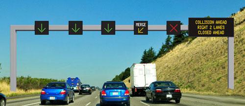
The possibility for us editors to close lanes on for example highways.
We'd indicate which lane is closed and a RoadShield like box would appear showing arrows so that users can change lanes early to the non close ones.
The_luxemburger
2 votes -
Mile markers on highways
It's almost the same as exit numbers
2 votes
- Don't see your idea?