
Map Editor Suggestions
Welcome to the Map Editor's suggestion box!
This is the place to share your ideas for improving the Waze Map editor.
1709 results found
-
Impossible for Level 1 to advance
As a level 1 editor, you need to gain experience to learn how to properly apply edits to the map for the betterment of the community. But as a Level 1 editor, you essentially can't edit anything. I understand not allowing a novice editor to make changes and potentially break the map. I understand there could be malicious actors who could sabotage this platform. But as it stands now, this voluntary map editing feature will die.
The amount of edits needed to move up levels is high. I'm fine with that IF edits are allowed. Sooner or later, the senior…
4 votes -
Keep usernames in WME history instead of "inactive user"
Whenever an user is banned or deletes his/her account or just mysteriously (!!) loses his/her account, all edits in history will be shown under name "inactive user" with a link to 404 page.
Just, for the sake of history, please keep the original username in history and add a little remark that the account is inactive/deleted/etc..
4 votes -
Replace Delete button for Save in the MTE form
When I want to put in a MTE lots of time I press on the delete knop after finishing instead of the save button.
May be the trash button can be used to delete the form and replace the delete button for saving4 votes -
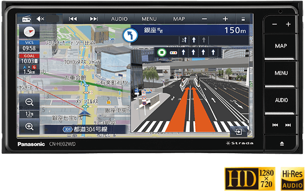
I would like to see a navigation function with detailed diagrams. (Since I am using a translation function, the text may be unnatural.)
nice to meet you. I am editing waze maps in Japan. I don't speak English so I use translation software. Therefore, there may be some parts of the text that are incorrect, so please forgive me.
Japanese car navigation systems have a function that displays a diagram that reproduces the shape of the intersection and which road to turn to when passing through an intersection or junction. However, that feature only supports some intersections.
It looks like the diagram on the right side of the screen in this image: https://panasonic.jp/car/navi/products/HA02_HE02/img/top/pic_01.png
Therefore, I would like to request that waze introduce such…4 votes -
colocar vias para bicicleta
podermos colocar vias de bicicleta no mapa
4 votes -
In alerts, add a button to report that there is a fixed speed bump in the road.
In the alerts the user can report, having a button to report that there is a fixed speed bump in the road would be useful.
4 votes -
Natural sequence for house numbers
Is necessary to enable the insertion of house numbers that are a sequence of natural numbers (Ex.: 101, 102, 103, 104, ....), which is very common in several condominiums in Brazil.
4 votes -
Allow the toggle of speed camera notification
Currently it seems you only get notified of a speed camera when going above the speed limit. Which admittedly comes in handy most of the time however when smart motorways reduce the speed limit, Waze won’t notify you fully, compared to if you were going above the speed limit of a normal motorway. Possibly either inform you fully all the time or allow there to be a setting for people that wish to use this feature would be very helpful.
4 votes -
Correction- Brazil
In Brazil, using English directions, many highways are designated as "SP-###", which stands for "SãoPaulo". The audio direction is calling out ALL SP highways as "Sulfur mono Phosphide" which is a chemical formula abbreviation S P. Every time an SP hwy is called out, she literally says "sulfur mono phosphide" each time, rather than São Paulo, or simply SP. Needs correction. Very annoying 😑
4 votes -
Average Speed Camera Location
Give the ability to pinpoint the location of the camera's that are being used for ASC's.
It adds another layer of information (besides the speed check zone announcement) to the map and avoids users reporting these ANPR-camera's as regular speed camera's.
4 votes -
Implementation of an App to be able to edit | Implementación de un App para poder editar
Hi 👋🏼 I have a suggestion that will change completely to improve the Efficiency of all editors and it is nothing more and nothing less than to implement an app for editors that allows us to edit like google maps only that the advantage of Waze is that it is more secure and reliable by the hierarchies. having the WME tool in our palm gives us the power to edit at any time and anywhere giving more constant tracking and updates without having to wait to get home or somewhere safe.
Cheers!Español:
Hola 👋🏼 tengo una sugerencia que cambiará…4 votes -
Show only POI which are along the route to destination
Show only POI which are along the route to destination. While a user is driving, typically user will like to see POS like Gas Station, Coffee Shop, Hair Salon which is along the route in SAME direction as his/her destination.
Make UX simpler so user can pick POI which are along the route in 1, 2 miles or 5, 10 minutes increments.
4 votes -
Report Occurrence of the integrated rescue system
Hello, would it be possible to add a warning about the presence of components of the integrated rescue system to the report on the occurrence of obstacles? (it is the unified designation of Firefighters, rescue services and police)
4 votes -
I want to make a route with a lot of stops
as i said in the title, I want to make a route with point A, point B,C D, etc.. i can't find a way to do that in the app.
4 votes -
elevation on map all time
to show elevation on map all time like speed
4 votes -
Enhanced Road Type Attributes for Improved Route Planning
I’d like to suggest an enhancement to the Waze road attribute system to improve route planning in regions with diverse road types. Currently, Waze allows drivers to identify paved and unpaved roads; however, many cities, including mine, have roads with unique surfaces, such as cobblestone or "stoned" roads, which can significantly impact vehicle mechanics and increase wear and tear.
Proposed Solution:
Additional Road Surface Options: Include new road attributes, such as "Stoned/Cobblestone" roads, alongside "Paved" and "Unpaved."
User-Selectable Avoidance Options: Allow drivers to choose to avoid certain road types like "Stoned" roads, which can affect vehicle stability and wear.
Condition…4 votes -
Speed limit visibility
When you pass the speed limit, for example riding a motorcycle, it becomes very difficult to read the actual speed.The speed indicator should be bigger, and when you traspass it, it shold have more contrast. I simply can´t see it on my phone. Maybe, as an option, the user could set the size and color of theese thins on screen. Thanksss
4 votes -
Indiquer les voies bloquées dans l'onglet "Fermetures" de WME
Bonjour,
Serait-il possible d’ajouter une option dans l'onglet "Fermetures" de Waze Map Editor pour indiquer précisément quelle voie est bloquée ? Cela permettrait d’utiliser les flèches de l'onglet "Voies et largeur" pour spécifier les fermetures plus en détail.
Merci !
4 votes -
Bring back pave roads
Bring back the "Pave Road" function in the phone app.
If this makes a lot of duplicate roads, even them out, or make it easy to remove the wrong ones/ keep the good one..
Also bring back the "Pacman-style road verification" that was here 10 years ago.
4 votes -
Message from a user reporting the end of a closure, does not indicate the location
As a map editor, we can sometimes insert numerous closures in one day, due to construction or traffic events.
When a user reports that a closure is no longer active, I, as the editor who created it, receive a message in my application. However, this message only indicates the information that the user reported. Example: “This road is not closed”
This does not provide additional information, such as the name of the road or even the location’s PL. If I create a lot of closures, I can’t identify which location it is.4 votes
- Don't see your idea?