Map Editor Suggestions
Welcome to the Map Editor's suggestion box!
This is the place to share your ideas for improving the Waze Map editor.
1623 results found
-
Events tab should ask to enable the Road Closures layer
When you select the Events tab, no events will show unless you have the Road Closures layer enabled. When you click the Events tab, there should be a pop up asking "Enable the road closures layer to edit events" with an Enable button, same as when you select the Road Closures tab for a segment if the layer is off. Having the layer off could confuse editors about why they don't see any events listed.
1 vote -
Temporary downgrade of own editor level
I’d like to suggest in the WME a switch (perhaps in the user control panel) for downgrading the own editor level.
For example:
If I’m a level 5 Editor, but only want to edit simple streets which are only on level 1, i can switch my own editor level to something lower than 5 for this action. This would prevent myself for accidental editing more important street e.g. highways.
Compare this with an account in the IT… Even if I am an administrator… I shouldn’t be logged in always as an admin but just as a normal user with rights…24 votesThanks for your feedback. At this time, this doesn't fit on our roadmap, but we'll keep it in mind for future product planning.
-
TR-panel shouldn't cover the TR-arrows
I've the impression that the behavior of the TR panel is changed. The panel remains longer visible after clicking one of the TR arrows. Nice in certain circumstances. Not so nice if you want to set all TR arrows of a crossing and some of the arrows are covered by the panel.
Suggestion:
Place the panel a bit further away from the crossing, making all TR arrows reachable.
The little triangle pointing to the selected arrow could be lengthened.15 votes -
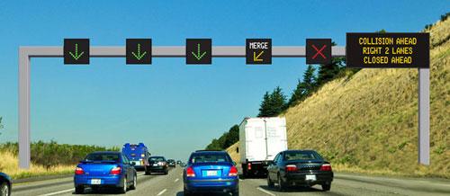
Lane closures
The possibility for us editors to close lanes on for example highways.
We'd indicate which lane is closed and a RoadShield like box would appear showing arrows so that users can change lanes early to the non close ones.
The_luxemburger
2 votes -
Use of alternate city names for routing
Several years ago the decision was made to use the postal city as an alternate city name for routing to addresses in rural areas. According to Wazeopedia "Waze founder and CTO Ehud stated in a US meetup that a search algorithm is so much work to build correctly and maintain, that Waze does not want to spend the time, money or energy to build their own, and are happy to stack the Waze matching process on top of the Google search algorithm." As a result, WME editors have spent untold time and energy adding the postal cities to these segments.…
29 votes -
Select entire street also by any of its alternative names
In some cases, it would be helpful to select an entire street not by its main name, but by one of the alternative names that it may have.
For instance, here in Portugal we have a big mountain area where it is needed to apply recurrent road closures due to bad weather (heavy snow). Because road closures are carried out by the authorities in perfectly delimited areas, the Portuguese community decided to put exactly the same name on ALL roads of a same area, even if the real street name is a different one. By doing this, the option ‘Select…
73 votesThanks for your feedback. At this time, this doesn't fit on our roadmap, but we'll keep it in mind for future product planning.
-
Put the House number field before the Street field
In some countries, House number needs to be before Street. Maybe this can be customisable by country? If not, I believe it's more logical to have House number first (smaller to larger).
141 votesThanks for your feedback. At this time, this doesn't fit on our roadmap, but we'll keep it in mind for future product planning.
-
Not a helpful shortcut
Funneling drivers onto Dinnick Crescent (Toronto) at rush hour instead of continuing to the light at Mt. Pleasant and Lawrence actually creates a worse, or equally bad lineup, as there is no ability to turn left (west) onto Lawrence. The traffic on Lawrence is solid for several blocks and drivers don't make room for those turning left, which then creates a lineup of cars on Dinnick with angry drivers who want to turn right. It would save time to simply stay on Mt. Pleasant and wait for the light.
1 vote -
No feedback provided if permalink is unable to select items
Currently there is no feedback given if one or more items are not selected when opening a permalink (i.e segments, places, URs, etc.).
For instance, I have a document with PLs of segments that are always closed during events (such as stadiums). If a segment ID is changed and therefore no longer linked in the PL, I have no way of easily knowing this.
Please consider providing some sort of warning if WME is unable to locate all the linked items.
58 votesThanks for your feedback. At this time, this doesn't fit on our roadmap, but we'll keep it in mind for future product planning.
-
Exit numbers on freeways that change the voice instruction
In some countries, including here in Australia, freeway exits often have exit numbers on the signs. Currently, we include these in the ramp segment's name. This means that, for example, a voice instruction may sound like this:
"In 1 kilometre, exit to the left onto Exit 24: C407 - Clyde Road to Berwick"
You can see how the word "exit" is repeated. If we could mark exit numbers on the map, then the voice instruction could give a more natural sounding sentence, for example:
"In 1 kilometre, take exit 24 on the left onto C407 - Clyde Road to Berwick"
…
8 votes -
set none as default when selecting an event for real-time closures
Most of the closures I add to the map (95%) need no traffic event associated with them because this is a minor use case.
Now I still have to click the event field and select none manually every single time which takes unnecessary effort and time. In the meantime I could have added other closures.
Therefore,, it would be a huge improvement if none was pre-selected.
30 votesThanks for your feedback. At this time, this doesn't fit on our roadmap, but we'll keep it in mind for future product planning.
-
Real-Time Speed limit
In relation with the time based speed limits, it would be interesting to have the possibility to change speed limits in real time.
In some european countries for example they limit the speed limit on all the highways in a country to 90kph due to too high Co2 levels.Having this option would set waze apart from other navigation apps.
30 votes -
Clear direction cache when WME edits are made
Often when WME edits are made affecting routing to an address, the Wazer still gets the same incorrect routing because the old data is cached. Then editors get another UR because the Wazer thinks the changes were never made, and we have to explain how to clear the incorrect data from the cache. That can be a problem for those who are technologically-challenged. Not to mention time-consuming for editors who have to walk them through it, sometimes exchanging multiple messages with the Wazer. Can Wazedev find a way to automatically clear incorrect data from the cache when edits have been…
10 votes -
About adding a river in the waze editor
About adding a river in the waze editor
It takes a very long time to add a river
I think it would be easier if you could write a river as easily as you would write a road.
1 voteThanks for your feedback. At this time, this doesn't fit on our roadmap, but we'll keep it in mind for future product planning.
-
Allow roadshields with more than 5 characters
Hi,
Would it be possible to increase the number of allowed characters for the roadshields.
In Luxembourg, for example we have roads like the "CR189A" which sadly doesn't fit into the inbox.Best Regards
The_Luxemburger L3 for Luxembourg6 votes -
WME road closure history information
In WME, editors are able to see road segment information and current road closures. At the moment, after road closures end, there is no visibility of what the road closure was in relation to and how long it was set for. This makes it a bit difficult when editors receive URs from road users and are unsure what the issue is related to.
It would be handy to see historical road closure information on that segment (if it be within the last 30 days or for the life of the segment).
3 votes -
Correction needed for Savannah historic district
From 16 into Savannah, GA. WAZE dictated a right turn on Abercorn but said "Abersham" so I missed the turn. That area is full of one-way streets and Abercorn would have "circled the block" to get me to Lincoln Street.
3 votes -
Map Editor: Check level abuse / change policy to gain better level
On Map Editor it's near to impossible to gain better level.
Some users are usual to block to level 3,4 or 5 segment like dead end street in residential area or park path. If you ask to unlock a segment, nobody do it or maybe somebody "steal" the update.
So high rank users get every day more point, for user also with map competence it's an infinite purgatory.
Please ensure1 vote -
GPS announces what state or county you're in
It will be nice if the GPS would announce the state, county and city you entered in because on the road the signs might be knocked down or you just might not see them while driving especially on the highway or minor roads I really think this needs to be a thing it'll be nice if it will announce what city You just entered in.
17 votes -
Notification in WME for tile build delay
If there is a delay in the tile build or the map is rolled back for some reason, please show a notification in the WME.
29 votesThanks for your feedback. At this time, this doesn't fit on our roadmap, but we'll keep it in mind for future product planning.
- Don't see your idea?