Map Editor Suggestions
Welcome to the Map Editor's suggestion box!
This is the place to share your ideas for improving the Waze Map editor.
1658 results found
-
When reporting traffic jam other drivers should be able to say "Not There" whenever it clears up
There are sometimes warnings for a traffic jam with slowness or standstill and the traffic has cleared up, however it seems to stay there on the map for ages.
This needs to be prompted to the users in the same way. Asking "Still there?"
4 votes -
Abandoned Car & Trucks on Shoulder Hazards shortcut
The "Car on Shoulder" is becoming a standard warning for mostly just abandoned cars, the problem with this is there could be a genuine hazzard where there is a car slightly hanging over or someone changing their tire, three car pile ups, etc.
The problem of the vagueness of "car on shoulder" is being overused. It should stay, but we might need others like "Abandoned Car" and "Truck on Shoulder" for like a tow truck or a semi-truck with a blown out tire or a larger vehicle on or near the road.
3 votes -
Report a People on the Road or Generic Hazzards Icon
When there are dangerous situations on roads like an accident or car pile up or someone has had a load loose or changing their tyre, these are way more dangerous than the overly used "Car on Shoulder" hazzard, which people put for abandoned cars. We will also need an Abandoned Car hazzard i rekon.
But people near the road is an actual hazard i want to know about.
3 votes -
Hazard addition to go to suggest an edit
Let all editors add Permanent Hazards but since it is locked by level they can be moved to "Suggest an edit" so spamming with permanent hazards or fake hazards are not added to the map.
35 votesGreat thinking! We’ll share with the team; they’re always interested in new feature ideas.
-
Default expiration date for map comments
There are a vast number of map comments without an expiration date that are no longer relevant. This causes map editors to open them to read the comments.
I suggest that when adding a map comment, the default expiration date be one year later, and the user can delete the date to make the comment permanent. This will hopefully minimize the number of "junk comments" in the map.7 votes -
remove auto zoom out after suggesting an edit
when a suggestion is made, it zooms the map out which causes lag
1 vote -
edit geometry/allow saves whilst adding closures
be able to edit geometry of segments that have active closures, as currently to edit geometry (without affecting node id) is to remove closure edit geometry and then re-add closure. as well as that allow the ability to add closures whilst having unsaved edits.
6 votes -
Supprimer la restriction des numéros de rue pair/impairs en France
En france, les numéros de rue pairs et impairs ne sont plus obligatoirement du coté droit et gauche.
Voir la fin de la réponse émise au Sénat :
https://www.senat.fr/questions/base/2002/qSEQ020700534.html#:~:text=demande%20à%20M.-,le%20ministre%20de%20l'intérieur%2C%20de%20la%20sécurité%20intérieure%20et,impairs%20de%20l'autre%20côté.3 votes -
Thanks
Probleme avec la map, a chaque fois que je signal qqch, je ne vois plus mon kilométrage, le temps quil me reste à faire, ca ne fait que dire merci d'avoir signaler. Jme fiche du merci, jveux avoir mes info! Vraiment désagréable, je dois fermer et reouvrir l'application, et renvoyer mon itinéraire a chaque personne concernée. On s'entend que ce ne devrait pas être, surtout sur la route! Tres désagréable!
Le remerciement ne devrait pas exister, ou si vous y tenez, inscrivez le ailleurs pour ne pas empêcher de voir les données de navigation
3 votes -
Aceitar a sugestão de novas rotas
Que seja aceito a edição online do mapa, para percurso definido pelo usuário, e não somente pelo caminho que o app entende por melhor, pois há vias que, mesmo mais longas e com pedágios, são melhores que as usuais!
4 votes -
House Number Mode Delete/Trashcan
With the new House Number editing mode, with the segment selected and actively editing house numbers, using the trashcan removes the segment and not the house number.
If I'm editing house numbers, the house number I have selected should be the object deleted. This is not a consistent behavior across WME.
12 votes -
Resumen de viaje
Sería muy útil que al final de cada viaje aparezca un resumen con la distancia recorrida, el tiempo de viaje total, la velocidad máxima y la velocidad promedio del viaje. Dado que con frecuencia repetimos los viajes, p.e. de la casa al trabajo y la ruta inversa, también podría incluir un comparativo de distancia y tiempo para esa ruta.
4 votes -
Colocar acceso directo a botón(es) para la creación de lugares
Crear unos botones de acceso directo para crear rápidamente lugares/puntos, y no tener que esta abriendo el menú contextual para cada creación, tambien el sistema a veces no guarda los nombres de los lugares y queda en blanco, si al sistema se le pudiera agregar que detecte cuando ocurre eso y envie un aviso o ponga el "pin" con rojo o algún color único para ubicarlo mientras editamos, gracias.
1 vote -
Route bar
Hello,
i would like to have a "Route Bar" on the screen. TomTom has it and it is great. You can see Petrol stations that are directly on your route, traffic incidents, speed camerasda, nger zones, rest stops and so on along your route.
6 votes -
Turn openings (temporary green arrow)
I loved "turn closures", but now I see the need to have "turn openings".
For example, a left turn is usually prohibited (red arrow). However, due to an event occurring on the next block, this left turn is temporarily allowed (green arrow) for a few hours on a specific day.
This is a common situation and, depending on the location, can save a lot of time by avoiding an unnecessary detour of several kilometers.
4 votes -
follow the screen display of Apple Maps and display the miles and time to destination along with the exit number on a highway
follow the example of the navigation screen display of Apple Maps and display the miles and highway exit numbers
1 vote -
Radar
Alguns radares o waze não avisa mesmo com o alerta ligado e acima da velocidade, favor consultar os órgãos de acordo com a resolução 798/20 e 804/20
3 votes -
Vias proibidas a pesados
poder colocar nas vias um local demonstrando a proibição a pesados ou por ser proibido por sinalização ou por ter arruamentos muito estreitos
1 vote -
Third Lane Ahead Warning for Drivers in BRAZIL
I would like to suggest that Waze use a notification on Brazilian roads, similar to the ones already in place for speed bumps and potholes, to indicate the presence of a third lane on highways.
This would be very helpful since many roads in Brazil do not have dual lanes, and when a third lane does appear, it is extremely useful for all drivers.
Additionally, this notification could help reduce overtaking, as drivers would be warned in advance about the third lane ahead, allowing them to avoid unnecessary overtakes, thus reducing the risk of accidents.
1 vote -
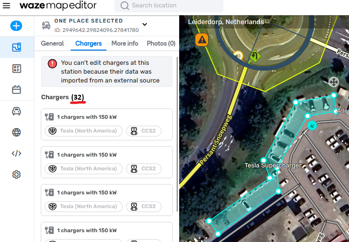
Counter for Chargers at a Charging Station
Please add a counter to charging station tab Chargers. Once you need to scroll (~7+ charging points), it's difficult to assess how many chargers there are. Example: this Tesla Supercharger: https://waze.com/nl/editor?env=row&lat=52.16064&lon=4.54912&zoomLevel=20&venues=2949642.29824096.27841780
Just something like this would suffice: https://i.postimg.cc/90z5LZ8z/afbeelding.png
27 votesGreat timing! We’re currently working on it. Keep an eye out for updates on the WME.
- Don't see your idea?