Map Editor Suggestions
Welcome to the Map Editor's suggestion box!
This is the place to share your ideas for improving the Waze Map editor.
1659 results found
-
I would like to see a navigation function with detailed diagrams. (Since I am using a translation function, the text may be unnatural.)
nice to meet you. I am editing waze maps in Japan. I don't speak English so I use translation software. Therefore, there may be some parts of the text that are incorrect, so please forgive me.
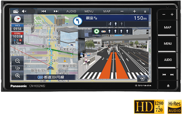
Japanese car navigation systems have a function that displays a diagram that reproduces the shape of the intersection and which road to turn to when passing through an intersection or junction. However, that feature only supports some intersections.
It looks like the diagram on the right side of the screen in this image: https://panasonic.jp/car/navi/products/HA02_HE02/img/top/pic_01.png
Therefore, I would like to request that waze introduce such…4 votes -
Add a category for schools in the mobile app version of Waze
Please add school categories with icon on the mobile app
1 vote -
Advance warning for speed limit changes
I drive a tracked vehicle, I need to be at the new speed limit before passing the signs. ie, 60mph dropping to 40mph, if the signs are hidden round the corner, I need to brake harder to slow down in time.
Would it be possible to have either a visible marker on the moving map to display the different speed limit up ahead, or a warning pop up maybe 200yds in advance?
7 votes -
New Permanent hazard: Check-point
In many countries, fixed check-points are installed on the road. It could be done by Police, Customs, Tax services, Weight check... and even borders.
It would be great to have those marqued on the map as permanent Hazard " Check point". It has basically the same effect of a toll booth: You often need to stop there, or a least drive through at a very reduced speed.
This would be a great safety enhancement for both drivers and those manning those check points.
31 votesThanks for your feedback. At this time, this doesn't fit on our roadmap, but we'll keep it in mind for future product planning.
-
import kml kmz files
suport import kml kmz files
3 votes -
Could we add a bus feature for people who rely on public transportation?
Could we add a bus navigation feature for people who rely on public transportation?
1 vote -
Make easier to select segments
Sometimes we need to do a bulk alteration in several segments, like to change max-speed, directions and so. Although it is possible to select all the street, sometimes, we don't need to change all the segments in the street.
Also, if a person has some mobility disability or dificulties, it is common they lost their selection of several segments because either clicked in a wrong place or not hold the ctrl key.
The suggestion is either a creation of a 'Selection mode' that can be activated and allows the user to click in the desired elemnts or a checkbox like…6 votes -
Edit Requests.
Allow editors that aren't a high enough level to edit certain things to be able to request an edit and a higher level can approve it.
6 votes -
Provide info of editor level nearby to help approve requests for changes
Provide help so business owners can have their place listed and approved
1 vote -
Default new users in US and UK to Imperial units
Since the wonderful new Edit Suggestions tool has been released, we have seen many (too many) suggestions from well-meaning users in the US to change speed limits to values like 16 or 31 mph. Obviously these users were set by default to use metric units without realizing it.
If a user tries to edit using the WME for the first time in a country that uses Imperial speed limits (which I believe is only the US, UK, Anguilla, Antigua, Barbados, and the Cayman Islands), their units should automatically be set to Imperial by default.
53 votesGreat timing! We're currently working on defaulting new users in the US and UK to Imperial units. Keep an eye out for updates on the WME.
-
Satellite
Satellite in Navigation
6 votes -
Enable Undo-Button
Enable an Undo-Button for giving a wrong warning/hint.
2 votes -
Inserção de pontos de portaria e/ou guarda.
Seria interessante a inserção de pontos de entrada/saida de acessos lindeiros, portarias, guardas ou entradas de condomínios, Etc. Incluindo restrição de visitantes e horários de aceso autorizado.
1 vote -
Allow Junction Boxes and Paths to exist together
When editing, there are many times that you need to restrict a turn that would require the use of a Junction Box (JB) to accomplish. The issue is that if a different route, that does not fit in the JB, needs to have Paths set up, we have to choose one or the other.
We need the ability to set Paths through a JB
600 votesGreat timing! We’re currently working on allowing Junction Boxes and Paths to exist together. Keep an eye out for updates on the WME.
-
Replace Delete button for Save in the MTE form
When I want to put in a MTE lots of time I press on the delete knop after finishing instead of the save button.
May be the trash button can be used to delete the form and replace the delete button for saving4 votes -
Allow combining chargers when merging EVCS
When merging EVCS, give users the option to include both sets of chargers. For some reason, some networks (ahem, ChargePoint) sometimes list multiple charger sites in the same parking lot or garage. If we try to merge them, we have to select one or the other set of chargers. Please add an option to include both sets.
47 votesThanks for your feedback. At this time, this doesn't fit on our roadmap, but we'll keep it in mind for future product planning.
-
Enable Voice alert for approaching Speed bumps
Hello Waze Team,
It would be so helpful for all Wazers to receive Voice alerts when approaching a speed bump so that we can prepare ourselves to slow down before approaching the speed bumps, as actually speed bumps has been added but it does not appear or notify you via voice alert that we are nearing a speed bump.
Grateful to look into adding voice alert when approaching speed bumps.
Thank you,
Kushal
16 votes -
Polygons in WME should just be a thick border instead of a full fill
To allow for easier interaction with polygons and segments & places inside polygons, change the polygons to be a thick border instead of it being a filled polygon.
With the expansion of features that include many polygons beyond just places (JBs, Permanent Hazards, Natural features, etc), it would make it much easier to work with these shapes.OpenStreetMap does this very well.
114 votesThanks for your feedback. At this time, this doesn't fit on our roadmap, but we'll keep it in mind for future product planning.
-
Keep usernames in WME history instead of "inactive user"
Whenever an user is banned or deletes his/her account or just mysteriously (!!) loses his/her account, all edits in history will be shown under name "inactive user" with a link to 404 page.
Just, for the sake of history, please keep the original username in history and add a little remark that the account is inactive/deleted/etc..
4 votes -
Narrow Road Permanent Hazard
This permanent hazard would warn users of an upcoming section of narrower road width that has traffic and/or safety considerations. Potential applications include:
Areas where a two-way road transitions to a single-lane width where opposing traffic must alternate/give way through the narrow section
• Ex. 1: https://waze.com/en-US/editor?env=usa&lat=41.26449&lon=-75.78368&marker=true&zoomLevel=18&segments=502096154
• Ex. 2: https://waze.com/en-US/editor?env=usa&lat=42.10978&lon=-71.24117&marker=true&zoomLevel=18&segments=74434220,22554146
• Ex. 3: https://waze.com/en-US/editor?env=usa&lat=44.33295&lon=-73.28244&marker=true&zoomLevel=19&venues=187892155.1879052625.3735122Two-way roads of limited width where common parallel/street parking cause drivers to have to move in or out of the parking lanes to allow traffic from no parking direction to pass
• Ex. 1: https://waze.com/en-US/editor?env=usa&lat=40.02695&lon=-75.22336&marker=true&zoomLevel=18&segments=41758956,41751608,41747111,41755005
• Ex. 2: https://waze.com/en-US/editor?env=usa&lat=41.88316&lon=-71.35791&marker=true&zoomLevel=17&segments=43507359,43531672
These are strictly permanent hazard warnings…
105 votesThanks for your feedback. At this time, this doesn't fit on our roadmap, but we'll keep it in mind for future product planning.
- Don't see your idea?