
Map Editor Suggestions
Welcome to the Map Editor's suggestion box!
This is the place to share your ideas for improving the Waze Map editor.
1717 results found
-
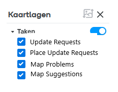
Add sublayers to Task layer
Please add sublayers to the Task chart layer in WME, just loike there are for almost all other chart layers. Besides bringing it in line with other layers, it will also save editors click, because instead of going all the way to filtering in the Review menu, they can just simply flick it off in the layers menu.
It would look something like this: https://i.postimg.cc/BvpqBXQk/Task-layers.png
3 votes -
Warn editors before hitting the daily proposal limit instead of failing on save
Currently, Level 1 editors are limited to submitting 10 edit proposals per day. However, the editor UI does not indicate when this daily quota has been exhausted.
As a result, an editor can continue selecting locked segments, making extensive adjustments, and editing attributes—only to receive an error ("Editors are only allowed 10 proposals per day") when finally attempting to save. All of that un-submittable work is then essentially lost or blocked.
Suggested improvements:
Visible Counter / Indicator: Display a counter in the WME interface showing remaining proposals for the current 24-hour window (e.g., "Proposals remaining today: X/10").
Proactive Warning: When…
3 votes -
Dynamic "Emergency Vehicle Approaching" Highway Alert
A crowd sourced, real time alert system designed specifically for high speed corridors (highways/freeways) that warns drivers to clear a lane before an approaching emergency vehicle (EV) reaches them.
How It Works:
Initial Report (The First Trigger)
A driver on a highway taps Report > Hazard > Emergency Vehicle Approaching.
To minimize distraction, this can be triggered via Voice Control.
Direction and Speed Tracking
Waze tags the report with the reporter's direction of travel and GPS coordinates.
Waze's backend uses real time traffic flow data to project the EV's probable direction and speed along the highway stretch.
Verification and Cascading…3 votes -
Flock cameras notifier
We need flock camera notifier on the Waze app. Flock camera has been everywhere and can we add a feature to notify where they are and a feature to select the route to the destination avoiding all or most of the flock camera.
3 votes -
Master chief line performances and lines
Not sure what this category nor where to put this. But i absolutely hate when master cheif calls me a soldier. Im uniquely from a position like him. Its SAILOR, SHIPMATE, MARINE, DEVIL, DEVILDOG. NOT SOLDIER! THATS ARMY! Everyone Master cheif worked with was MARINES and Sailors. I absolutely love that yall changed some lines around like him talking about the Covenant, there was some cool *** lines like "finish the fight" but that should be like on the longer or around when u have to do like 2+ back to back turns, or if your getting off the freeway…
3 votes -
Suggestion for improvement: Voice notification when entering a city
Hi, everyone!
Recently, while traveling, I found myself missing a feature that I think could be very useful in Waze: a voice notification when entering a city.
The idea is that, when crossing a city boundary while navigating, Waze would announce something like: “Welcome to [city name]!”
This would be especially useful on highway trips, since many cities don’t have visible or well-placed identification signs, making it hard to know exactly when we’re entering or passing through a city.
In addition to making the trip more informative, this feature would help drivers better orient themselves along the route without having…
3 votes -
Actual scale option for map viewing
One improvement I think would be worth implementing in Waze is offering a true-to-scale map view option, in addition to the current zoom feature.
In some situations, especially when driving within cities, I find that the map is zoomed out too far, making it difficult to see the details of roads, intersections, and nearby access points. This can make navigation less intuitive, especially in areas with many streets close together.
My suggestion would be to allow users to choose between the current view, with adjustable zoom, and a true-to-scale mode, which would maintain a more accurate representation of distances and…
3 votes -
Add a layal available to Area Managers to see issues in transit to aid in cartouche updates.
Add a layal available to Area Managers to see issues in transit to aid in cartouche updates.
3 votesGreat thinking! We’ll share with the team; they’re always interested in new feature ideas.
-
Allowing to fill missing information in locked area map in editor
In locked area map, please allow to fill at least the missing information such as road's name, city and so on.
3 votesGreat thinking! We’ll share with the team; they’re always interested in new feature ideas.
-
Improve satelite image
In "Valera, Venezuela" the satelite image of Google is a real mess. I really loved the former images from the waze map. Do something google because your satelite image is not helping me to edit the roads in my city
3 votesGreat thinking! We’ll share with the team; they’re always interested in new feature ideas.
-
אפשרות להצעת שינויים על דרכים נעולות
להוסיף אפשרות בעריכת המפה לשלוח הצעות לשינויים נעולים. שתהיה האפשרות לשלוח הצעה לשינוי דרכים נעולות עקב רמה נמוכה
ואם אפשר בבקשה להסביר בצורה יותר טובה איך עולים שלבים, כמה נקודות כל שלב, ואפשרויות לעלות שלבים מהר לרציניים3 votesGreat thinking! We’ll share with the team; they’re always interested in new feature ideas.
-
Selecting a search result shouldn't reset the zoom level
When using the WME search box to find a road, it would be really nice if WME could leave the current zoom level well alone rather than always resetting it to level 3.
Even if it just defaulted back to level 4 that'd be an improvement, but jumping back out to 3 means we then always have to zoom back in at least one step if we want to be able to select a street segment. And even at L4, anyone looking to do some work on point places would then need to zoom in one step more before they…
3 votes -
Improvements in segment selection for road closures
Sometimes it's necessary to select multiple segments to perform a road closure either for MTE or for a conventional closure. After you have several segments selected, you accidentally select a node and all work is lost (the section disappears). I suggest making a modification that prevents the disappearance of the selection of these segments and notifies the editor that you selected a node and it will not be possible to make the respective closure (before or at the moment of trying to save). Obviously the idea is to give you the opportunity to remove the node from the selection and…
3 votesHey!
Thank you very much for this great suggestion.
It was added to our backlog to try and see the possibility to implement it.Please note there is no ETA for it yet.
Best,
Hezi -
New Place Address
I'm not sure if it's a minor-bug or intended, but I ask you to take a look:
Issue regarding Map Editor Beta and Production.
:arrow: When you find a new place waiting for approval, if you click on the red arrow everything runs smooth, but if you feel the need to click on the yellow arrow to check what's that place is about before approving it (sometimes you can't tell just by the name title), notice it isn't possible to change the address... well maybe it's ok at this point before approving it.
(attachment 1)
After you Approve you can't…
3 votesHey!
Thank you very much for this great suggestion.
It was added to our backlog to try and see the possibility to implement it.Please note there is no ETA for it yet.
Best,
Hezi -
Address localization
lease allow localization of address field just as it is done in search results, so it would be possible to have "%{street} %{housenumber}" instead of "%{housenumber} %{street}" for some languages.
by matsalka
Link to original suggestion: https://www.waze.com/forum/viewtopic.php?f=1525&t=2810563 votesHey!
Thank you for this suggestion, We will be happy to hear more on what will be the added value of this suggestion, if the info is presented in the correct way today already.
Thanks,
Hezi -
Drive to Feature on Cartouche
While editing the map I would like a separate layer so that I can make notes and pin it to areas of the map that I would like to visit. These online notes should only be viewable by the user who made the notes. It would also be necessesary to navigate to these Points of Interest and have the notes pop up so that pictures can be taken of the surrounding so that the Waze map can reflect real world situations out there on the road.
The Waze notes layer (home computer) and the Android phone should be synced so…
3 votesThanks for your feedback. At this time, this doesn't fit on our roadmap, but we'll keep it in mind for future product planning.
-
Color-coded according to speed in editor
A feature that had been good when you are editing speed limits would be to go into a "Edit mode for the speed limit" just as the house number.
That all roads would be color-coded according to speed. and roads with no speed would be gray, so you can easily see which roads have the limitation and which have not.Another thing that would be great is that you can put limits whereever on the road and not just at a crossing. Again, just as the house number.
3 votesThanks for your feedback. At this time, this doesn't fit on our roadmap, but we'll keep it in mind for future product planning.
-
Vehicle restricted closures
Now: the closures are for all vehicles.
SUG: possibility of applying a closure for a certain type of vehicle and not for others, for example: closures only for taxis.
Idea by brooha40
Link to the original suggestion in beta forum:
https://www.waze.com/forum/viewtopic.php?f=1525&t=3020173 votesThanks for your feedback. At this time, this doesn't fit on our roadmap, but we'll keep it in mind for future product planning.
-
Show house numbers on smaller zoom
Currently the layer of house numbers only works on the the zoom levels 7-10. Please enable it starting from zoom 5.
By: lg1992
Link to the original suggestion: https://www.waze.com/forum/viewtopic.php?f=1525&t=3015853 votesThanks for your feedback. At this time, this doesn't fit on our roadmap, but we'll keep it in mind for future product planning.
-
Parking Lots: Show Payment Types only when needed
Please consider showing the 11 payment types checkboxes only when the "Cost" dropdown has "Low", "Moderate" or "Expensive" selected.
This will help you to have consistent information too: For example, what does it mean that a free parking log accepts Credit Cards as a payment type?
by bedo2991
Link to original suggestion: https://www.waze.com/forum/viewtopic.php?f=1525&t=2755293 votesThanks for your feedback. At this time, this doesn't fit on our roadmap, but we'll keep it in mind for future product planning.




- Don't see your idea?