Map Editor Suggestions
Welcome to the Map Editor's suggestion box!
This is the place to share your ideas for improving the Waze Map editor.
1632 results found
-
2 votes
-
trucking industry
We need to add an icon on the Waze app for truckers to add locations where they have Ministry of transportation or people pulling over trucks to do inspections this is a must we would pay for this service
2 votes -
מפת ניוט ליעד ביניים
שלום רב
כאשר מבקשים לנווט ליד משנה המפה מובילה לחניון ואז לא ניתן לנווט ליעד סופי...
לדוגמא אבן גבירול 124 למגדל המאה בתל אביב כיעד משנה מחייבת כניסה לחניון ולא מאפשרת לעבור ליד הסופי
עמוס2 votes -
With SO many SILVER cars out there, could we “at least” offer a silver car as an option ?
A small personalization.
2 votes -
Shops and services
It's missing
TABAC TOBACCO
PRESSE PRESS2 votes -
Pot holes
When waze warns of upcoming hole can it say which lane it is in
2 votes -
Mapa modo satélite
Mapa modo satélite
2 votes -
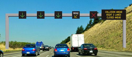
Lane closures
The possibility for us editors to close lanes on for example highways.
We'd indicate which lane is closed and a RoadShield like box would appear showing arrows so that users can change lanes early to the non close ones.
The_luxemburger
2 votes -
Allow editor comments in URs
Allow editors to add comments to URs that do NOT go the reporter.
Editors often have suggestions for possible reasons for URs, that other editors may not be aware of.2 votes -
Mile markers on highways
It's almost the same as exit numbers
2 votes -
andere gebruikers
een mogelijkheid om een route en/of bestemming door te sturen naar andere gebruikers zou handig zijn. voor allen die naar dezelfde plaats moeten rijden
2 votes -
Posibility to add type of plug and charge speed for EVCS from the app.
Costa Rica is not on the list of countries where Waze has implemented the features for EVCS.
Here are more than 1000 charging stations between L1, L2 and L3 and we have added almost all of them in Waze manually.
We have to introduce all the characteristics of each charging point in the app from the WME.
It would be great if it can be done from the app. Like adding plug type or charging speed. From the application it is not yet possible.2 votes -
Creazione di indicatori di rischio
Per creare indicatori di rischio oggettivi integrando i dati ACI-ISTAT con quelli che segnalano gli utenti su fattori che concorrono al rischio. https://www.aci.it/laci/studi-e-ricerche/dati-e-statistiche/open-data.html
2 votes -
Light mode and dark mode intergration for android auto
Add integration so that when your vehicle head lights in your vehicle turn on it turns the map to dark mode instead of light.
2 votes -
Country Manager
The Country Manager should be a local editor as we know the changes to the road, we are driving in the country, not a foreigner using satellite images to edit the map.
Some accidents are caused by drivers heavily depending on waze at night as they know its updated but now its not .
2 votes -
Setting to see only issues reported or commented by me
Please add a (easy to find) setting to see only the issues that I have reported or commented on.
When I select the "Filter" function "Filter map issues", in the section "Update Requests (URs)", under "My actions", I select only "Reported by me", I expect that the results show ONLY issues that have been... reported by me.
2 votes -
WME - Categories.
Hi.
Please, allow us to suggest different types of - Categories to be added into WME.
Thanks!
2 votes -
voice controll over waze
Voice controll when waze is on and the voice controll is on as well.
Just say "Waze danger", it will ask what kind of danger, you say on road it confirm you say after that car stop, or wheather, fog... etc...
It recognise the item and ask to confirm, you say yes and you made a sign without to watch and manual input the danger.
Namaste2 votes -
תיקון כתובת של עסק
היי אני צריכה לתקן כתובת של עסק בבני ברק שמפנה לגבעתיים, איך אפשר לעשות זאת?
2 votes -
hight of vehicle
selected the hight of your vehicle for parking towers. If you have a rooftop on your car you can't enter a parking tower lower than 2 meter
2 votes
- Don't see your idea?