Map Editor Suggestions
Welcome to the Map Editor's suggestion box!
This is the place to share your ideas for improving the Waze Map editor.
1633 results found
-
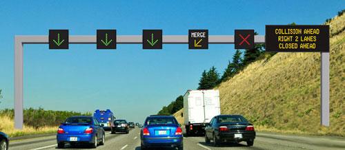
Lane closures
The possibility for us editors to close lanes on for example highways.
We'd indicate which lane is closed and a RoadShield like box would appear showing arrows so that users can change lanes early to the non close ones.
The_luxemburger
2 votes -
Drivable Areas
The current solution for parking lots and gas stations is not particularly user friendly. A user driving within these areas is directed to follow parking lot road segments which can be very complex and still may not represent the paths that drivers actually follow.
A means to give a user a general instruction to proceed to a particular exit to get going on their route could result in a better user experience, especially in the case of of multi-level parking structures where a user may drive in circles repeatedly as they proceed to the exit level.3 votes -
Solucionar problemas
Hola, les comento lo que me pasa, en Argentina en una avenida de doble mano no es permitido girar a la izquierda. Y peor aún a las 7.30 en hora pico.y otra cosa,como tiene el norte fijo hacia arriba hay veces que indica girar en sentido contrario. "?" Sería bueno si corrigen por lo menos éstos problemita. Muchas gracias!!!
1 vote -
Apply alternative name to all selected segments of the street
Today, if an alternative name is only assigned to some segments of a street, and you select also segments of the street without the alternative name, there is no indication of such status and no way to apply the alternative name to all segments. Please add such indication and action.
16 votes -
Changement de nom de rue
La rue Villeneuve à Terrebonne, Qc Canada a été changé depuis plusieurs années pour rue Jean-Louis, Terrebonne,Qc Canada, J6W2A7
1 vote -
New "comment" category: traffic cam
It can help editors a lot to have quick access to traffic cameras or similar government-deployed cameras that are accessible for the public.
Certain places have mapped them in WME with a Web Comment (point), but it might be useful to have a distinct category for them, so they are easy to spot.
It can be simply a duplicate of the existing comment category, but with a new symbol.9 votes -
Add filter to WME feed
Add state filter to the UR feed
To be able to focus on editing a state, il would be good to be able to filter the feed mainly when managing a country or multiple states.
11 votes -
Markers for Emergency Service Stations
An awesome addition to the waze map editor would be the addition of emergency service station markers and permanent building markers / icons with two types for example:
Emergency tap (single tap on any of the icons will add it to your route)
- Hospitals (Marked with a red and white "H")
- Police Stations (Marked with a house shape outline & a badge inside)
- Fire Stations (Marked with a house shape outline & Fire Axe or fire truck inside)
Passive Icons
- Schools (that have a highlighted zone area around them when route passes though and an alert…11 votes -
Closures - Don't return to top of list
When you have a lot of closures on a segment, Waze goes back to top of list each time you open one of the closures in the list. This makes it more labour intensive if you have to go through several to change settings. It should be constructed in such a manner that when you cancel or save a closure, you return to the same position in the list.
14 votes -
Integrate camper vans into parking spaces
I would like to have the possibility to integrate mobile homes into parking spaces. But also to offer the possibility when parking spaces are only allowed for motorhomes.
Greetings Martin5 votes -
Allow roadshields with more than 5 characters
Hi,
Would it be possible to increase the number of allowed characters for the roadshields.
In Luxembourg, for example we have roads like the "CR189A" which sadly doesn't fit into the inbox.Best Regards
The_Luxemburger L3 for Luxembourg6 votes -
Multiple opening hours per day
Having the possibility to enter multiple opening hours for each day.
Some shops are open from e.g. 09:00 to 12:00 and 14:00 to 18:00. Currently you have to enter each of those times for each day seperately.11 votes -
minimize the URs window
in the URs window we have "x" button but we dont have minimize button "-", Some times it block viewing the Waze provided route & User drive (GPS trace) to study it. So if we have the minimize button who need to minimize it he can.
4 votes -
Left panel configurability
Problem for me and apparently for many other people too is that some left panel items I frequently need are on the bottom part and need to scroll to reach those while others I very rarely need are visible all the time. Solution: Make left panel configurable in a way that you could change the order sections appear in it.
For example I would like to see History, Created by and Last edited by fields higher and would drop height and lock levels to the bottom of the list, it would result in much better usability for me.
6 votes -
Dark Mode in WME
You know you want it.
An example of what it could look like: https://imgur.com/a/9ckUEVf
56 votesThanks for your feedback. At this time, this doesn't fit on our roadmap, but we'll keep it in mind for future product planning.
-
Update Request - View recently cancelled route
It would be extremely helpful on Update Requests to provide the route/path information for a recently cancelled route.
Often users report an issue shortly after cancelling a route that gave them bad instructions. In these cases, editors can't see what the Waze app was asking them to do, versus what they actually did. Often users forget the precise details of what the bad instructions were.
If this is already permitted to some degree, perhaps widening the time window my a couple of minutes would help capture more of these.
3 votes -
WME Road Types
The current classification of roads on the WME follows the road types in the USA (Freeway, Major and Minor Highways and other road types).
In Europe, but I think also in other parts of the world, the classification of roads is very different. This creates problems with editing roads, as it is difficult to adapt the WME type to the real situation.
It is necessary to revise the road classification of the WME according to the real classification of each country so that each country can edit the map in a correct and more real way.26 votesThanks for your feedback. At this time, this doesn't fit on our roadmap, but we'll keep it in mind for future product planning.
-
Attach files to update requests
Allow users and map editors to attach files (images, pdf and such on) to URs
26 votesThanks for your feedback. At this time, this doesn't fit on our roadmap, but we'll keep it in mind for future product planning.
-
Messagerie par mail avec adresse de reponse
Les messages des éditeurs de carte ne fonctionnent pas.
Message d’erreur loups someone is wrong’
Merci de me contacter par mail avec une adresse de réponse.
Cordialement
Serge1 vote -
Events tab should ask to enable the Road Closures layer
When you select the Events tab, no events will show unless you have the Road Closures layer enabled. When you click the Events tab, there should be a pop up asking "Enable the road closures layer to edit events" with an Enable button, same as when you select the Road Closures tab for a segment if the layer is off. Having the layer off could confuse editors about why they don't see any events listed.
1 vote
- Don't see your idea?