Map Editor Suggestions
Welcome to the Map Editor's suggestion box!
This is the place to share your ideas for improving the Waze Map editor.
1631 results found
-
Improved Notifications in WME
I suggest adding in WME notifications to improve tracking of URs and map notes:
- Followed URs: Receive notifications directly in WME (not only on the mobile app) when there are updates or new replies.
- Followed map notes: Receive notifications inside WME (not only by email) when new comments are added to notes I am following.
These improvements would make it easier to stay updated, respond faster, and enhance community collaboration without relying only on email or the mobile app.
28 votes -
Fix the lane width and lane guidance interface
You have "Number of lanes" listed twice for two different things. 1) the number of lanes at the start of the segment (incoming used for lane width) and 2) number of lanes (outgoing used for lane guidance arrows).
Recommend having the lane width changed to "Incoming number of lanes" and lane guidance changed to "outgoing number of lanes"
Yes after you get used to the current configuration it can be figured out but it is never a good practice to have two different items with the same label on a single interface.
Also the Displayed lane guidance arrows are just…
28 votes -
Adding Traffic Lights to the Map
It would be very helpful if Waze displayed traffic lights on the map. This feature would allow drivers to better anticipate delays at intersections, adjust their speed smoothly, and avoid sudden braking or collisions. It would also improve the accuracy of travel time estimates and help Waze suggest alternative routes that avoid long red lights or heavy congestion. Additionally, showing traffic lights would assist drivers in timing their turns more effectively, reducing the chance of missing them due to unexpected stops or light changes.
28 votes -
Allow choice in HN street name
Hi
Certain streets have a different name or city depending of side.
It would be great to allow, when adding HNs, editors to specify what name we want to assigne to it when alternate bloc is filled.Thanks
28 votesThanks for your feedback. At this time, this doesn't fit on our roadmap, but we'll keep it in mind for future product planning.
-
New Permanent hazard: Check-point
In many countries, fixed check-points are installed on the road. It could be done by Police, Customs, Tax services, Weight check... and even borders.
It would be great to have those marqued on the map as permanent Hazard " Check point". It has basically the same effect of a toll booth: You often need to stop there, or a least drive through at a very reduced speed.
This would be a great safety enhancement for both drivers and those manning those check points.
28 votesThanks for your feedback. At this time, this doesn't fit on our roadmap, but we'll keep it in mind for future product planning.
-
Ability to hide or move individually each native issue tracker filter
Please provide the ability to hide or move down the list, individually, each WME provided Issue Tracker filter.
WME has 4 supplied Issue Tracker filters
All issues
Starred
Unread
Actionable URsThis request is for WME to have a Hide button next to each filter tracker so that we could hide it in the drop down list. Alternately, please provide us with the ability to move these filters down the list.
For those of us who have created custom filters, we may want those filters at the top of the list (especially if we have many filters) so we want…
27 votes -
Indonesia ETLE Camera
In Indonesia, all traffic enforcement cameras operate under one unified system: ETLE (Electronic Traffic Law Enforcement) Camera.
To ensure accuracy in WME, provide clarity on which camera type is valid, and avoid confusion among Indonesian editors, we'd like to request a dedicated Indonesia ETLE camera type that reflect the applicable traffic enforcement regulation for Indonesia.
27 votes -
Include Permanent Hazard (PH) changes in segment history
Currently, when a Permanent Hazard (PH) is added or updated in a segment, no record is created in the segment's history.
Ideally, changes to their attributes should be tracked, but for now, recording when they are added or updated would be very helpful.
27 votes -
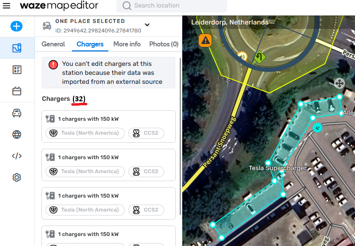
Counter for Chargers at a Charging Station
Please add a counter to charging station tab Chargers. Once you need to scroll (~7+ charging points), it's difficult to assess how many chargers there are. Example: this Tesla Supercharger: https://waze.com/nl/editor?env=row&lat=52.16064&lon=4.54912&zoomLevel=20&venues=2949642.29824096.27841780
Just something like this would suffice: https://i.postimg.cc/90z5LZ8z/afbeelding.png
27 votesGreat timing! We’re currently working on it. Keep an eye out for updates on the WME.
-
Do not move my map somewhere else after an edit
Hi,
when editing from the feed (closing MP, UR), after saving WME moves to a random place where it thinks there are other UR I can solve. It is extremely annoying. When editing I save often because of various save bugs, and as soon as I saved it moves somewhere else and I cannot find where I was editing to finish the job.
Same problem when saving, if Waze thinks there is a problem it moves my map to where it thinks the problem is, and if it is a long road, it happens often that the road is offscreen.…27 votesHey!
Thank you very much for this great suggestion.
As we believe this will be solved with a release of related features, we added to our backlog to track and make sure it was solved.Best,
Hezi -
27 votes
Thank you for reaching out. We don't have enough details to thoroughly investigate this idea so we will close it now. If this idea is still relevant, please submit it again and include all relevant details.
-
Link points POI to an Area POI
Hi guys,
The idea is to link points POI to a Area POI.
For example, linking stores in a Mall or linking a company office in a building.
It's also to avoid this kind of editions : https://www.waze.com/editor?env=row&lon ... 157&zoom=6.
I think this will help editors to determinate which stores or companies are present in a Mall/building and help user to use the right entry to go to shopping or working.
It will be a plus if you can also link, a point POI entry on an Area POI entry.by Ardillon42
Link to original suggestion: https://www.waze.com/forum/viewtopic.php?f=1525&t=27817927 votesThanks for your feedback. At this time, this doesn't fit on our roadmap, but we'll keep it in mind for future product planning.
-
Make RPPs a bright pink
Change the colour of the RPP from a camouflaged dusky pink (same shade used to literally camouflage reconnaissance Spitfires in WWII) to a bright pink like #fa0584 to make it more visible in urban backgrounds.
27 votesThanks for your feedback. At this time, this doesn't fit on our roadmap, but we'll keep it in mind for future product planning.
-
Filter Segment Closures
It would be great to have the option to filter closures on a segment. e.g. Hide all finished by default, only display active closures, only display upcoming closures etc
27 votes -
Remember orientation when dragging Street View handle
When the Street View handle is dragged onto the map and subsequently moved again, the orientation snaps to north. It would be helpful to maintain the current heading so that when moving the handle along a street the heading doesn't have to be repeatedly rotated back parallel with the street.
27 votesThanks for your feedback. At this time, this doesn't fit on our roadmap, but we'll keep it in mind for future product planning.
-
Add the ability to search segments by ID in the WME
Add the ability to search segments by ID in the WME
26 votes -
Multilingual street names
Add the capability to add translations to street names so people who speak different/foreign languages can use the map. EX: In Israel, Google Maps has Anglicized street names, while Waze does not. As a result, the English-speaking voice in Waze cannot recite street names in Waze.
This feature would be of great use in NYC and other cities where there are plenty of ESL speakers and people who have very limited understandings of English. Spanish would be a great language to start with.
26 votes -
Allow applying A->B closures on B->A segments (and vice versa)
When selecting a one-way segment with a closure, and another segment without a closure, it is currently possible to select "Apply on all" to extend the closure to the second segment.
This only works if the second segment has the same one-way direction of the first segment.
When a segment with an A->B/B->A closure is selected, add a new option "Apply closure in any direction", which applies the currently selected closure as "both" on all additional selected segments.
26 votes -
Flock Safety license plate readers
With Flock Safety license plate readers becoming so widespread and concerning can we start adding those as we see them?
26 votes -
None as default for street and city in new segments
Submitted on behalf of the IL community: Why isn't a default value of "no street", "no city" entered in the address field of a new segment? New editors don't always fill out the address field and it remains "no address", creating a need to contact them and explain to them how to choose "no" for the street name.
26 votes
- Don't see your idea?