Map Editor Suggestions
Welcome to the Map Editor's suggestion box!
This is the place to share your ideas for improving the Waze Map editor.
1656 results found
-
Allow sending Update Requests closing message when the map update succeeds
Send the UR closing message to the user when the map really gets updated (contains all changes up to the UR "closing" time).
Some things may get fixed immediately (by adding a closure or updating a place), most things require a map update. That means that we always have to write stuff like "in few days/after the next map update, the problem will be fixed".
Maybe a third button like this:
"Mark as Solved"
"Solve on map update" <-
"Mark as not identified"When the second button gets clicked a form opens when I can write a message to the…
24 votes -
Update UR Categories the same as the App
Would like to match app problem descriptions with those presented in WME URs.
For example: UR's that come in for 'Wrong Driving Directions' (what the App says)
Show in WME as 'Improper / Poor navigation instruction'Having that changed to 'Wrong Driving Directions' will help with editors looking at responses and what to select for a default/1st response to a user.
24 votes -
Remove false city names from UK WME database
Following the mass import of data for 3 ad campaigns (McDonald's, M&S, Aldi) by the Ads / Geo-ops teams the UK map is now littered with false or incorrect city names. These must be removed from the map immediately as they are NOT city names and should not exist.
The UK Champs have asked privately for this to be done but for some reason this request needs to be public.
This is NOT a change to UK mapping, this is simply following common sense that Counties should never be used as a city name and fake city names should not…
24 votesHey Chris,
As your community manager have also communicated to you via email, this request was sent here by mistake.
We will keep on supporting it with in the correct flow.
Best,
Hezi -
Enforce better minimum segment lengths
WME currently allows segment lengths down to 1 m. However, editors are told that Waze will not measure traffic speeds accurately over such short segments and that mapping them could degrade the end-user experience. Different regions may have different recommendations for minimum segment length, but if anybody knows the best minimum length, it should be Waze itself. If Waze will not function properly with extremely short segment lengths, then WME should not allow them.
24 votesThanks for your feedback. At this time, this doesn't fit on our roadmap, but we'll keep it in mind for future product planning.
-
Temporary downgrade of own editor level
I’d like to suggest in the WME a switch (perhaps in the user control panel) for downgrading the own editor level.
For example:
If I’m a level 5 Editor, but only want to edit simple streets which are only on level 1, i can switch my own editor level to something lower than 5 for this action. This would prevent myself for accidental editing more important street e.g. highways.
Compare this with an account in the IT… Even if I am an administrator… I shouldn’t be logged in always as an admin but just as a normal user with rights…24 votesThanks for your feedback. At this time, this doesn't fit on our roadmap, but we'll keep it in mind for future product planning.
-
Combine HNs and RPPs with best features of each
Combine HNs and RPPs with the best features of each. The current system of two different ways of showing house number, plus the need to change modes for HNs, is time-consuming and counter-productive. They need to be combined with capabilities such as interpolation, use on any type of road and searchability on all.
23 votes -
sign with passkey (windows or google)
please add authentication by windows passkey (hello) or Google passkey (no login/pass + email confirm)
23 votes -
Speed limit update requests to Production in ROW
Given that the appearance of SLURs has now calmed down I would like to make a proposal to move SLURs from beta to production editor.
There are, however, two questions to everyone in ROW:
1) can you reports SLs from app? New SLURs pop up from time to time, but I haven't been able to make one myself;
2) would you like to bring all previous SLURs to prod or have a reset and make a fresh start? My vote goes to "bring everything to prod", because the current amount and appearance of new ones is manageable.By: matsalka
Link…23 votesHey!
Thank you for this suggestion.As it was announced in the forum we are currently working on improving the SLUR workflow and user experience.
This suggestion will be taken into consideration in the work.So, thank you again we will update accordingly.
Hezi
-
Add closures provides by a partner feed to the history of a segment
Closures placed with WME can be traced back in the WME because they are added to the history of the segment. Closures provided by partner feeds are not added to the history. Adding them to the segment history makes it easier for the editors to find solutions for URs.
23 votes -
Remove multiple closures
If you have a list of closures that need to be removed, it would be good to have a way of removing them in one go. Either by a selection check box option, or just a single Remove All option.
23 votesGreat timing! We’re currently working on the feature to remove multiple closures at once. Keep an eye out for updates on the WME.
-
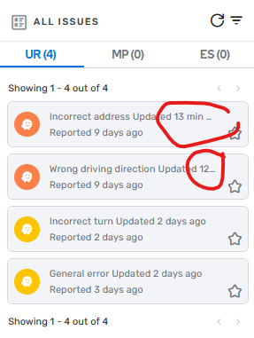
UR Menu - tooltip
The UR menu breaks off URs with a long category. This has the effect that you cannot see in the menu when it was last updated, and you have to open the UR for that. So I suggest to make a tooltip for those URs, or alternatively make it 2 lines instead of one.
23 votes -
Unsaved edits - apply to map without saving
Related to this announcement:
if there were an option to simply “apply” the unsaved edits to the map, without saving them (basically treat the unsaved edits as a draft) that would be awesome. Sometimes the browser crashes or something gets in a weird state while doing a complex edit (common use case where this happens a lot is dividing roads for the falcon snapper) and I have to start over.
I think the times when I have a crash in a place where I'm actually ready to save my changes are much rarer than when I'm in the middle…
23 votesThanks for your feedback. At this time, this doesn't fit on our roadmap, but we'll keep it in mind for future product planning.
-
Different speed limits for School zone Polygon depending on Entry Point
When creating School zones, i encounter the weird situation where the same segment has 2 different speeds, for example: when you go Southbound is 25mph school zone and for the same street but going Northbound the speeed is 15mph. in this case we will use the lowest speed but this wont be accurate, as the alert is telling users that the School zone is 15mph, mean while they going Southbound where the School sign shows 25mph, so this would create URs, complaining about the proper speed for the Soutbound lane, and this is what this suggestions is intended for so…
23 votesThanks for your feedback. At this time, this doesn't fit on our roadmap, but we'll keep it in mind for future product planning.
-
Allow for the addition of signage symbols for turn instructions.
I'm not asking for the ability to add all road signage (e.g. regulatory signage) as this would be overkill, but many countries include symbolism on big green signs to display additional services on a turn instruction without having to use lengthy text to do so.
While some symbolism exists in unicode/emoji form, these are not uniform across platforms and having country specific visual aids to add to signs would be a valuable way of informing drivers of additional services on their turn instructions.
The types of signs I would like to see added include:
* Accomodation
* Camping
* Caravan…22 votes -
Have the possibility to select BUS icon in LG
The request is very simple.
In WME when setting LG having the option to mark one lane as BUS (not with any direction or routing options behind it)
During Navigation display the arrows and BUS when Lane Guidance is shown.Example: Left Straight Straight Right one lane is bus
Shown as: Left Straight BUS Right during LG in waze22 votes -
Different layout for RPPs: visible numbers
Hi,
in my city there is a big number of RPPs due to side roads.
I often add them and, since there no way to copy-paste an RPP (this could also be a suggestion), I often copy road's name, then add the number and submit.
Maybe that sometimes I forget/miss to Apply road name/number, so I get no-way, no-city, no-number, but RPP's triangle doesn't allow me to notice my mistake.
It would be nice if (at least) the address number appeared on the RPP within the map, in order to check its value.
Another use for the enhancement would be…22 votes -
Mark gas station brands as "Top Tier"
When refueling, many drivers are much more interested in fuel quality than in the specific brand. But at present, the Waze gas-station finder offers no means to limit searches by fuel quality.
Waze can solve this problem by supporting the identification of brands selling "Top Tier" gasoline. "Top Tier" is a consortium of vehicle manufacturers that approves certain gasoline brands as preferred for their engine designs (toptiergas.com).
"Top Tier" designation is associated with all stations selling certain brands and not with any individual station. I'm not sure what mechanism to suggest for Waze to support editing a brand-wide feature like…
22 votes -
WME issues filter
Part of the daily work of map editors is to delete old URs via WME issues filter that have no activity.
Currently there is no way to filter URs older than N days and the only way to filter is to filter from date to date. This requires defining new dates each time and filtering cannot be saved.
The suggestion is to add a filter of "older than N days"22 votes -
Display summary of saved changes for all hazards in WME
In the current state when adding, modifying or removing any hazards (i.e. cameras, railway crossings, sharp curves, speed bumps, complex intersections, multiple lanes merging, toll booths, school zones and traffic lights) in WME, these edits show as pending changes when hovering over the save button.
However, after pressing the save button, the summary of saved changes does not show a summary of hazards added, modified or removed. It only says "saved".
I am suggesting to provide a list of changes made after pressing the saved button in WME.
22 votes -
Editing permissions - change request
I suggest to chane some editing pernissions as follows (the current required level is given in parenthisis):
- Giving a "narrow street" road type to a segment: 3 (1)
- Entering a TBR / TBTR (this includes difficult turn and toll road designation): 3 (1)
- Enter a turn instruction override: 3 (1)
- Delete a segment that someone else created: 3 (2)
- Create a new MTE: 4 (1)
- View RTC details (view only): 1 (4)
- View of house numbers: 1 (2)
22 votesThanks for your feedback. At this time, this doesn't fit on our roadmap, but we'll keep it in mind for future product planning.
- Don't see your idea?