 Bob McCormick
My feedback
125 results found
-
165 votes
Thanks for your feedback. At this time, this doesn't fit on our roadmap, but we'll keep it in mind for future product planning.
An error occurred while saving the comment -
21 votes
-
77 votes
Thanks for your feedback. At this time, this doesn't fit on our roadmap, but we'll keep it in mind for future product planning.
-
14 votes
An error occurred while saving the comment https://www.mass.gov/info-details/cooling-centers-guidance
I support this. While the demographic for people affected by extreme heat / lack of heating may not be Waze users, in many areas volunteers and possibly even ride-share drivers could be providing transportation and would benefit by this.
Above is a link for Massachusetts guidance on cooling centers. There is also a central database of this information albeit I don't believe accessible to the public. It may be possible to establish a partner relationship to get this info into Waze.
-
94 votes
-
99 votes
-
18 votes
-
116 votes
An error occurred while saving the comment This was also discussed in one of the roundtable discussions at the mega meetup Atlanta GA US 2024
An error occurred while saving the comment Now that we have closure history - there shouldn't be any reason to delete closures, which has been typically what we do when a closure needs to be terminated early.
What I have typically been doing is editing the closure and setting the time 2 minutes into the future. This effectively expires it. Change the delete button / functionality to expire would be a large benefit to maintaining closure history - which has become great for researching URs as well as adding future closures in areas of construction, etc.
-
91 votes
Great timing! We’re currently working on expanding the character limit for the name of an MTE. Keep an eye out for updates on the WME.
-
515 votes
Thank you for your valuable feedback. We're pleased to confirm that this suggestion is planned and we appreciate your input as we continue to enhance our product.
-
73 votes
Thanks for your feedback. At this time, this doesn't fit on our roadmap, but we'll keep it in mind for future product planning.
-
600 votes
Great timing! We’re currently working on allowing Junction Boxes and Paths to exist together. Keep an eye out for updates on the WME.
An error occurred while saving the comment What John said :)
I think the majority of where this combination exists is where a JB is used to restrict a U-Turn. The other alternative is to come up with a method of having a U-Turn restriction with something other than the JB.
-
47 votes
Thanks for your feedback. At this time, this doesn't fit on our roadmap, but we'll keep it in mind for future product planning.
An error occurred while saving the comment As an EV driver the Waze charging station places are not of a level of quality that I could rely on - we need to be able to clean up the map and the feed to really make this of value to Wazers.
-
105 votes
Thanks for your feedback. At this time, this doesn't fit on our roadmap, but we'll keep it in mind for future product planning.
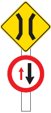
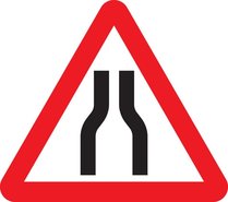
An error occurred while saving the comment Luke warm to this idea.
In some places like NZ I can see maybe value where there are things like one-lane bridges. For visitors who are not accustomed to driving there the warnings for signs like this may be helpful:
https://www.nzta.govt.nz/assets/resources/roadcode/gfx/one-lane-bridge-giveway-1.gif
(means you need to give way to oncoming traffic)Or in places where the road narrows, like in Pete's first few examples. In the UK and elsewhere you typically see a sign like this:
https://www.highwaycodeuk.co.uk/uploads/3/2/9/2/3292309/editor/road-narrows-on-both-sides.jpg
(Often the centre line goes missing and you only have paint on the edges of the road.) Many narrow roads have hedges, or worse yet, stone walls, right at the edge of the road. While I'm not sure I'd want to flag every narrow road, I think ones where there are particular challenges would make sense.Not in favor of the two lane street where one side can be used for parking - reality of high density urban areas - and hopefully Waze isn't regularly routing people down streets like that.
-
32 votes
An error occurred while saving the comment Wow - never tried to add a home address to the map - that's crazy amount of steps, and is confusing. And now that you've shared the process, as an editor it make a lot more sense what we are seeing in WME. Yes - this could be improved in the Waze client for the sake of Wazers, and it also benefits the editing community as well.
For RPP for residences, would make a lot of sense to require at least a house number and street, as often I find these kinds of things actually distant from where they should actually be located. Saves editors time where otherwise the only thing we can do is look at a photo (if provided) and if there's street view, try to figure out which dwelling it is - otherwise do that from comparison with aerial imagery.
-
95 votes
Hey,
Please note we're changing the status of this suggestion to Currently Not Planned, since we finalized our plans for 2024 and this idea won't be implemented this year.
We hope to include it in our plans for later down the line.
Thanks!
-
52 votes
Thanks for your feedback. At this time, this doesn't fit on our roadmap, but we'll keep it in mind for future product planning.
An error occurred while saving the comment I agree that the current color scheme doesn't really convey info that is very useful to me.
Age of GPS traces would be paramount in my mind. I would accept that being done with color coding, though I would much rather have a filter that could choose an age.
And maybe could be part of a revamp in this area. Please! Get rid of all the outliers with GPS traces that are just scattered about. Happens mostly in areas with possibly marginal mobile Internet connectivity, but could also be related to GPS quality as well. In many areas this "noise" just clutters the map, especially when it is close to legitimate traces.
-
11 votes
AdminElla (Waze Team) (Admin, Waze) responded
-
48 votes
Great timing! We're currently working on the ability to close places permanently or temporarily. Keep an eye out for updates on the WME.
-
360 votes
Thanks for your feedback. At this time, this doesn't fit on our roadmap, but we'll keep it in mind for future product planning.
An error occurred while saving the comment Anything we can do to improve Wazer - editor communications should be considered. My success rate in communicating with Wazers is under 20% and far too many URs are closed due to a lack of interaction with the reporter. The number of URs that I typically close based solely on the information provided to us in WME is almost nil.
Way too easy to have the new RRC PH snap to a RR segment. While this may be amusing for someone using Waze on a train, seems like this should be something simple to implement that would help ensure the proper placement of RRC PH.