Map Editor Suggestions
Welcome to the Map Editor's suggestion box!
This is the place to share your ideas for improving the Waze Map editor.
1632 results found
-
Sugiro a possibilidade de informação de lombadas nas vias
Possibilidade dos usuários informarem lombadas nas vias, como já existem as opções de informar outros perigos
16 votes -
Update your maps. Our address at 7230 Via Bernini, Rancho Murieta, CA 95683 is over a year old and the streets do not show up a
Update your maps. Our address at 7230 Via Bernini, Rancho Murieta, CA 95683 is over a year old and the streets do not show up on your outdated maps.
1 vote -
Issue tracker, disabling automatic refresh after closing for example UR
Issue Tracker is otherwise good but one part of it's behaviour is driving me nuts!
When you close for example an UR it refreshes the list automatically -> You lose track where you were on the list. So you end up clicking same reports over and over again every time you close something...
I liked the old UR list behaviour better when solved one's stayed on the list until you refreshed it, you never lost the track where you were on the list. And there is a refresh button on Issue Tracker so WHY does it also have to refresh…
66 votesGreat timing! We’re currently working on the option to disable automatic refresh. Keep an eye out for updates on the WME.
-
possibilità di inserire e seguire una traccia gpx
Sarebbe bello poter caricare una traccia GPX e poterla seguire con il navigatore
7 votes -
Add to all places the field “Located in venue”
The places of the Category "Charging Station" have the field “Located in venue”. The same field should be added to public places of other categories.
9 votes -
counterflow
Allow invert one way directions trhough interditions
7 votes -
"Check and try again"
Save error suggestions should provide useful, actionable info to the editor to help them know what to do to solve the problem.
"Check and try again" isn't helpful. Check what?
9 votes -
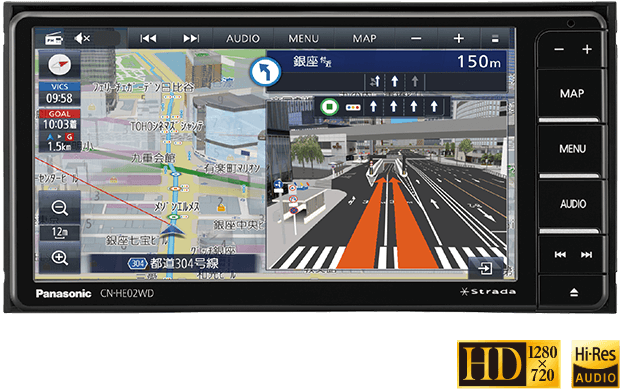
I would like to see a navigation function with detailed diagrams. (Since I am using a translation function, the text may be unnatural.)
nice to meet you. I am editing waze maps in Japan. I don't speak English so I use translation software. Therefore, there may be some parts of the text that are incorrect, so please forgive me.
Japanese car navigation systems have a function that displays a diagram that reproduces the shape of the intersection and which road to turn to when passing through an intersection or junction. However, that feature only supports some intersections.
It looks like the diagram on the right side of the screen in this image: https://panasonic.jp/car/navi/products/HA02_HE02/img/top/pic_01.png
Therefore, I would like to request that waze introduce such…4 votes -
Add keyboard shortcut for issue resolution buttons
Please add keyboard shortcuts for the Green and Grey buttons ("Not Identified" and "Solved" or their equivalents) options within URs/PURs/MPs.
30 votes -
Max/Min Speed Limit
The idea is to display a minimum speed limit also in blue color with a maximum speed limit (already available on the map). Most of the main Highways in the UAE have max & min speed limits. You can get a fine for driving lower than minimum speed also. for eg. E11 (110/60), E311 AbuDhabi side (140/120)
1 vote -
Zoom in to selected map suggestion
When we select a map suggestion in the Issue Tracker, the map is centered on the suggestion, but the zoom level isn't changed. The map should zoom in to the suggestion.
10 votes -
Street Parking
We have parking lot roads that cover most parking situations, but there's not a great mechanism for handling street parking on public streets where it doesn't make sense to mark a road as a parking lot road. Examples: Many residential neighborhoods, many downtown areas.
Suggestion is to add a flag to all driveable road types except freeway and PLR/PR to indicate "street parking is allowed", along with pricing information similar to how we handle parking lot areas. This could be part of the next phase of the parking project.
33 votesThanks for your feedback. At this time, this doesn't fit on our roadmap, but we'll keep it in mind for future product planning.
-
Closed Place - Permanent/Temporary
Suggestion:
"Place Closure" Feature.
Please provide an option for editors to mark any place as closed, preferably with permanent closure or temporary closure options. Based on these two choices, branching options should be displayed.
For example, if a place is marked as permanently closed, the reason should be displayed along with an option to delete the place from the map.
If it is temporarily closed, options for duration and reason should be shown.Additionally:
Display a warning to drivers before starting the journey, along with a red icon indicating that the place is closed.Many people I have spoken to…
48 votesGreat timing! We're currently working on the ability to close places permanently or temporarily. Keep an eye out for updates on the WME.
-
Disable and restore to default of the issue tracker filters
Please add two important features to the issue tracker:
1. Temporarily disable all filters in the issue tracker (show all URs, PURs etc.), without changing the filters, so that the editor can later on enable the filters in order to have the defined filters without the need to redefine them.
2. Restore the issue tracker to its default state, so that all the previously changed filters will be returned to their default state.
These features will be very useful.42 votes -
Disable street name popups on the map when using Apple CarPlay?
I have a problem with the map when using Apple CarPlay. The car's display shows constantly changing large, annoying blocks (popups) with street names. Those blocks often fall over critical parts of the map I'm just driving to. That's why I can't see where I need to go on the map. For example, an upcoming intersection will be completely covered. I use the map with the setting to always keep north at the top (just in case that makes a difference).
My proposal is to create an option in the settings to enable and disable these blocks. This makes the…3 votes -
Editing of primers for maps
I see in the application only two map views "default" and "map editors". I think it is interesting if you can choose the colors yourself, for example. Highway - blue, national road - red, etc.
1 vote -
Hazard (Speed bump)
In France (I don't know if other countries practice the same) we are faced with situations where speed bumps cover an entire intersection. Knowing that the current configuration only allows two-way signaling, I asked myself the question if we could not have the possibility of having the choice on a crossing and cross, a T crossing, a two-way crossing, A >B, B>A. Because if my deduction is correct today to cover such crossings we must put two Hazards so that the announcement is made from all directions of traffic.
Thanks for reading10 votes -
More informative options for the GPS layer colours (colour by speed or age)
Currently, the arrows on the GPS layer are coloured by direction. It would be useful for editors to be able to choose between that and at least two other options: colour by speed, to help editors understand historical traffic patterns and troubleshoot routing decisions; and colour by age, to help editors spot roads that may have been recently realigned or closed.
52 votesThanks for your feedback. At this time, this doesn't fit on our roadmap, but we'll keep it in mind for future product planning.
-
Speed camera cars
Have the option to post speed camera cars instead of clicking on Police
1 vote -
Allow photos to be used in reporting chats on WME
It should be allowed to insert photos in chats with users when they report a problem, this will make it easier for us to solve the type of problem that exists on the map. It could be a low resolution image only to better identify the problem
1 vote
- Don't see your idea?