Map Editor Suggestions
Welcome to the Map Editor's suggestion box!
This is the place to share your ideas for improving the Waze Map editor.
1632 results found
-
flooding
A tool to leave flooding points saved as if they were the user's favorites so that they can be activated and deactivated when necessary.
2 votes -
Waze Editor app
Make the editing easier with an app for android /and ios/
To make the editing fast and easier and accurate (in car)
Like adding street or speed cameras or even adding a buildings16 votes -
remove auto zoom out after suggesting an edit
when a suggestion is made, it zooms the map out which causes lag
1 vote -
Supprimer la restriction des numéros de rue pair/impairs en France
En france, les numéros de rue pairs et impairs ne sont plus obligatoirement du coté droit et gauche.
Voir la fin de la réponse émise au Sénat :
https://www.senat.fr/questions/base/2002/qSEQ020700534.html#:~:text=demande%20à%20M.-,le%20ministre%20de%20l'intérieur%2C%20de%20la%20sécurité%20intérieure%20et,impairs%20de%20l'autre%20côté.3 votes -
Thanks
Probleme avec la map, a chaque fois que je signal qqch, je ne vois plus mon kilométrage, le temps quil me reste à faire, ca ne fait que dire merci d'avoir signaler. Jme fiche du merci, jveux avoir mes info! Vraiment désagréable, je dois fermer et reouvrir l'application, et renvoyer mon itinéraire a chaque personne concernée. On s'entend que ce ne devrait pas être, surtout sur la route! Tres désagréable!
Le remerciement ne devrait pas exister, ou si vous y tenez, inscrivez le ailleurs pour ne pas empêcher de voir les données de navigation
3 votes -
Use URL to add external provider
Sometimes WME fails to locate a right matching place from Google Maps, but the place can be found with Google search engine. As a solution I suggest to enable WME to assign a matching place also by a known URL from Google Maps.
14 votes -
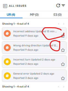
UR Menu - tooltip
The UR menu breaks off URs with a long category. This has the effect that you cannot see in the menu when it was last updated, and you have to open the UR for that. So I suggest to make a tooltip for those URs, or alternatively make it 2 lines instead of one.
23 votes -
new speed limit
In the app, report a new speed limit when a new sign has been placed or an existing one has been changed.
5 votes -
Colocar acceso directo a botón(es) para la creación de lugares
Crear unos botones de acceso directo para crear rápidamente lugares/puntos, y no tener que esta abriendo el menú contextual para cada creación, tambien el sistema a veces no guarda los nombres de los lugares y queda en blanco, si al sistema se le pudiera agregar que detecte cuando ocurre eso y envie un aviso o ponga el "pin" con rojo o algún color único para ubicarlo mientras editamos, gracias.
1 vote -
Drive with your friend(s) or Family
You can drive with your friends or family if you have a 2 or more vehicle convoy. This means if you loose a convoy member, you can find them on the map, and then set a route. All while your original route stays in a queue. You can also sent your friend(s) or family the route so they can set it up on their phone, car play or android auto.
9 votes -
לחצן "רכב נעצר בשולי הדרך
היי,ממליצה לקצר את התהליך ללחיצה על רכב נעצר בשולי הדרך. זו ההתרעה הכי נפוצה וכרגע נדרשים 3 שלבים כדי להתריע. . תודה
2 votes -
follow the screen display of Apple Maps and display the miles and time to destination along with the exit number on a highway
follow the example of the navigation screen display of Apple Maps and display the miles and highway exit numbers
1 vote -
]bz2012 ⑤ AM La: There is a problem I keep encountering: "accessable parking" is NOT allowed except for 'parking lot' places but many place
]bz2012 ⑤ AM La: There is a problem I keep encountering: "accessable parking" is NOT allowed except for 'parking lot' places but many places try to add the feature on non parking lot locations.
It should really be allowed anywhere customer parking is allowed.
9 votes -
Road shields, ability to add different sign as override to the major one used for that street name
In Finland, we currently have named roads as "180 - Saaristotie" etc. and would like to get rid of the number in street name and just leave the shield. But that is not possible because we have quite a few locations where road number changes while road name stays the same. Another problem is when road category changes to minor road so that the number drops off completely.
So there is a need for feature where you could set an override shield to selected segments while the default sign for that road name stays active on other segments.
12 votes -
Radar
Alguns radares o waze não avisa mesmo com o alerta ligado e acima da velocidade, favor consultar os órgãos de acordo com a resolução 798/20 e 804/20
3 votes -
Vias proibidas a pesados
poder colocar nas vias um local demonstrando a proibição a pesados ou por ser proibido por sinalização ou por ter arruamentos muito estreitos
1 vote -
Third Lane Ahead Warning for Drivers in BRAZIL
I would like to suggest that Waze use a notification on Brazilian roads, similar to the ones already in place for speed bumps and potholes, to indicate the presence of a third lane on highways.
This would be very helpful since many roads in Brazil do not have dual lanes, and when a third lane does appear, it is extremely useful for all drivers.
Additionally, this notification could help reduce overtaking, as drivers would be warned in advance about the third lane ahead, allowing them to avoid unnecessary overtakes, thus reducing the risk of accidents.
1 vote -
Speed limit visibility
When you pass the speed limit, for example riding a motorcycle, it becomes very difficult to read the actual speed.The speed indicator should be bigger, and when you traspass it, it shold have more contrast. I simply can´t see it on my phone. Maybe, as an option, the user could set the size and color of theese thins on screen. Thanksss
4 votes -
revisar y aprobar las sujerencias de los editores que tratamos de mejorar la experiencia del uso de waze...
he echo 3 intentos de nombrar una calle y ni tansiquiera lo toman en cuenta....
porfavor tomen en cuenta las sujerencias de hacemos
2 votes -
Add "New EVCS" to the PUR Types in "Filter Map Issues"
I would like to be able to filter out all the "New EVCS" PUR types.
17 votes
- Don't see your idea?